
Why Visit Yaxchilán?
Yaxchilán is a unique experience in Mexico's archaeological world. Unlike other sites like Palenque or Chichen Itza, Yaxchilán is accessible only by boat via the Usumacinta River, creating a sense of genuine adventure and isolation that few archaeological zones can offer.
This was one of the most powerful Maya cities during the Late Classic period (600–800 AD), rivaling Piedras Negras and forming strategic alliances with Bonampak. Its political and military power is reflected in monumental architecture and, especially, in the finest carved lintels ever created by the Maya.
What makes Yaxchilán truly special:
- River access only: The route to the city follows the Usumacinta River, one of Mesoamerica's most powerful rivers. The 40-minute boat ride is integral to the experience, with sightings of crocodiles, iguanas, and tropical birds.
- Remote location: Located on the Mexico–Guatemala border, Yaxchilán remains in the most pristine and least-explored jungle of the region.
- Incomparable lintels: Famous for their depictions of bloodletting rituals, warfare, and astronomical events. Many originals are in the British Museum (for historical reasons), but replicas on-site allow you to appreciate their beauty.
- Abundant wildlife: Howler monkeys, jaguars (if you're lucky), crocodiles, iguanas, and hundreds of bird species in an untouched jungle setting.
- Spirit of adventure: Yaxchilán attracts travelers seeking authenticity, not mass tourism. Groups are small and contact with nature is constant.
It's the perfect destination for those who want to combine world-class archaeology with the adrenaline of a genuine jungle expedition.
History: The Dynasty of Yaxchilán
Yaxchilán flourished as a political and military center during the Late Classic Maya period (approximately 250–900 AD), with its peak during the seventh and eighth centuries.
The legendary rulers:
- Shield Jaguar (Shield Jaguar I, 681–742 AD): The most famous ruler of Yaxchilán, who expanded the city's military and political power. His achievements are recorded in multiple lintels depicting him performing bloodletting rituals with his principal wife, Lady Xoc. Under his reign, Yaxchilán became a regional superpower.
- Bird Jaguar IV (752–768 AD): The successor to Shield Jaguar, he continued the tradition of military conquests and commemorative monuments. Many of the most impressive buildings you see today were constructed under his command, including the famous Structure 33, dedicated to celebrating his power.
Regional political context:
Yaxchilán did not exist in isolation. The city maintained complex relationships with powerful neighbors:
- Rivalry with Piedras Negras: Both cities competed for control of the Usumacinta River and surrounding region. Hieroglyphic records show repeated military conflicts, with victories and defeats on both sides.
- Alliance with Bonampak: Located just a few kilometers away (and accessible today by land), Bonampak was an ally of Yaxchilán. Cooperation between the two cities is documented in multiple hieroglyphic texts.
- Connections with major centers: Yaxchilán participated in the trade and political networks connecting Tikal, Calakmul, Palenque, and other major centers.
Decline and rediscovery:
Like other Maya cities, Yaxchilán was abandoned around 900 AD during the Maya Classic "collapse." Probable causes include prolonged drought, demographic pressure, and political conflict. The jungle reclaimed the city for more than a thousand years.
It wasn't "discovered" until 1882 when an Austrian explorer, Teobert Maler, found it almost completely covered in vegetation. His early photographs revealed the magnificence of the lintels and architecture, capturing the attention of the academic world.
Serious excavations began in the twentieth century, and today Yaxchilán is one of the most studied Maya sites, especially regarding lintels and their hieroglyphic content.
What to See at Yaxchilán?
Yaxchilán covers an area of approximately 40 hectares, though the most impressive buildings are concentrated around the Great Plaza and its surroundings. A typical visit lasts 2-3 hours of exploration with a guide.
The Great Plaza (Central Acropolis):
The ceremonial heart of the city. It's a broad expanse surrounded by structures on multiple levels. Public ceremonies, bloodletting rituals, and possibly ritual combat took place here (though less common than in other cities). The plaza is dominated by two main acropolises.
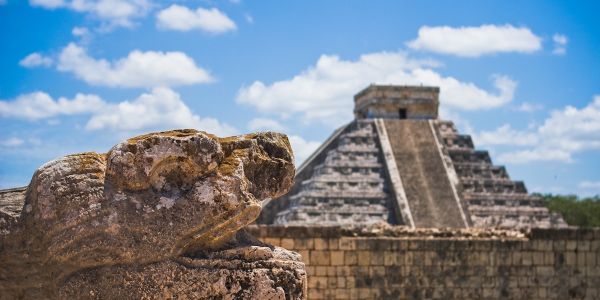
Structure 33 (Temple of Bird Jaguar):
One of the most photographed buildings at Yaxchilán. Built by Bird Jaguar IV in 758 AD, this temple sits on an elevated promontory with magnificent views of the Usumacinta River. Its lintels are among the best preserved and most artistically refined. The staircases are steep and require a degree of fitness to climb, but the view from the top is absolutely worth it.
The lintels of Structure 33 depict the ruler in poses of military and ritual authority, frequently accompanied by hieroglyphic annotations dating astronomical or military events.
Structure 40:
Another important temple with exceptional lintels. This building is also dedicated to Bird Jaguar IV and contains some of the most detailed scenes of combat and enemy capture. The reliefs show the brutality of Maya warfare, with representations of prisoners being humiliated.
The Labyrinth (Structure 45):
A unique structure whose name comes from its multiple interconnected interior passages and chambers. It's not entirely clear what the exact function of the Labyrinth was, but it's believed it may have served as an elite residence, storage chamber, or ritual space. Exploring its dark passageways is one of the most evocative experiences at the site.
The Main Acropolis:
A colossal structure that served as the residence of the royal family and administrative center. The access staircases show evidence of ancient stucco and paint work, though most has been lost. From the top, you have a panoramic view of the entire city and the Usumacinta River beyond.
Scattered carved lintels:
Throughout the site you'll find stones with partially deteriorated reliefs that are still identifiable. Some original lintels remain in situ (though many of the finest were removed and are now in museums), while others have been replaced with replicas for preservation.
Altars and stelae:
Scattered throughout the Great Plaza, these smaller monuments recorded dynastic events, enemy capture, and calendrical dates. Most are significantly eroded, but guides can help you interpret hieroglyphics that remain legible.
The Lintels of Yaxchilán: Masterpieces of Maya Sculpture
If there's something that makes Yaxchilán archaeologically extraordinary, it's its carved lintels. These are stone blocks that functioned as "frames" in temple entrances, and Yaxchilán's artists transformed them into genuine narrative masterpieces.
Why are Yaxchilán's lintels special?
Unlike other Maya sites where monuments were primarily stelae (upright stones) and altars (low horizontal stones), Yaxchilán elevated lintel sculpture to a supreme art form. Artists achieved a carving depth and narrative detail rarely seen at other sites.
The most famous lintel: Lady Xoc's bloodletting ritual
Lintel 24 from Structure 23 is perhaps the most celebrated Maya lintel in all Mesoamerica. It shows Lady Xoc, the principal wife of Shield Jaguar, performing a self-sacrifice ritual (bloodletting). In the scene, she perforates her tongue with a stingray spine (a well-documented Maya practice) while Shield Jaguar stands with a torch. A "supernatural being" or hallucination is believed to emerge from the spilled blood, representing contact with the spirit world.
This lintel is now famous because:
- It represents one of the most important themes in Maya cosmology: sacrifice as a means of communicating with the gods.
- The level of artistic detail is extraordinary: every feather, every glyph, every body line is perfectly executed.
- It documents a specific historical event (dated in the Maya cosmology) that the rulers wanted posterity to remember.
This lintel is now in the British Museum (along with many other Yaxchilán originals), but there are excellent replicas on-site.
Other notable lintels:
- Lintel 8 (Structure 4): Shows Bird Jaguar IV in a pose of authority, possibly during his "ascension" or enthronement. The details of his attire, jewelry, and power symbolism are extraordinary.
- Lintel 16 (Structure 21): A battle scene with warriors capturing enemies. The violence of Maya warfare is depicted rawly, with bodies writhing and blood (symbolically represented).
- Lintels from Structure 33: A series of lintels dedicated to Bird Jaguar IV depict his reign, military conquests, and participation in state rituals.
Why are many lintels in London?
In the nineteenth and early twentieth centuries, when access to Yaxchilán was much more difficult (and the area virtually uninhabited), some explorers and collectors removed lintels from the city to "preserve" them in European museums. The British Museum ended up with a significant collection. Today this is viewed as part of the colonial legacy of art looting, though some argue Western museums provided better preservation than would have been possible in the tropical jungle.
The good news: replicas of many lintels are at Yaxchilán, allowing you to appreciate the art even if the originals are in London. Guides can show you exactly which are originals and which are replicas.
Hieroglyphic decipherment:
The hieroglyphics on Yaxchilán's lintels were crucial to modern Maya hieroglyph decipherment. Epigraphists were able to cross-reference historical citations and calendrical dates across multiple lintels to build a chronology of rulers and events. Yaxchilán was one of the first sites where Maya political history "came alive" through hieroglyphics.
The Usumacinta River Adventure
Getting to Yaxchilán is part of the experience. Unlike traditional archaeological zones where you drive to the entrance, Yaxchilán requires a forty-minute boat journey through the Usumacinta River, one of Mesoamerica's most powerful rivers.
The Usumacinta River:
The Usumacinta originates in the mountains of Guatemala and flows northward, forming the natural border between Mexico and Guatemala for hundreds of kilometers. It's a voluminous river, especially during the rainy season, and plays a central role in the region's geography and ecosystem.
During pre-Hispanic times, the river was not a barrier but an "aquatic highway" connecting Yaxchilán with other cities like Piedras Negras (in Guatemala) and likely downstream cities. Maya cities were strategically located along the river to control aquatic trade.
The boat journey:
Typical boats are small motorized launches piloted by local navigators who know every rapid, every curve, and every danger on the river. The journey lasts approximately 40-50 minutes from Frontera Corozal (the nearest town).
During the trip you'll see:
- Lush jungle vegetation: Trees over 40 meters tall, vines, epiphytes, all in a state of tropical growth without significant human interference.
- Crocodiles: Especially visible on calm banks. They are American crocodiles (Crocodylus acutus), generally shy of humans but still impressive.
- Iguanas: Often seen basking on branches hanging over the water.
- Birds: Woodpeckers, toucans, parrots, herons, cormorants. Guides can identify them and interpret jungle sounds.
- Fish: You'll occasionally see golden fish (more common) or larger fish jumping.
The landing site:
The boat leaves you at a small beach on the river bank, exactly where ancient Maya probably disembarked 1,300 years ago. From there, a short walk along a vegetation-covered trail takes you to the base of the Main Acropolis.
Safety:
The river is generally safe for tourist travel. Local navigators know the river well and have decades of experience. Accidents are rare. The only real risk is sudden rain (which can cause waves quickly) or bad weather, which occasionally causes the trip to be canceled. Overall, while the experience is an "adventure," it's fairly controlled.
Practical considerations:
- Wear clothes you don't mind getting wet (river spray is almost inevitable).
- Use sunscreen (water reflection intensifies the sun).
- Cameras should be protected from moisture and spray.
- Don't carry too much luggage; bring only essentials.
- If you have motion sickness issues, take medication before the trip.
- Respect the border: Guatemala is visible across the river, but it's just observation. Don't attempt to cross.
The return:
The boat waits on the beach during your visit to the site. Typically, a group spends 2.5-3 hours exploring Yaxchilán, then the boat returns to Frontera Corozal with the same group. The return is generally faster because the river flows in a southern direction, so you're back in town after approximately 30 minutes.
How to Get to Yaxchilán?
Yaxchilán has no direct road access. You must first reach Frontera Corozal, the nearest town, and from there take a boat to the archaeological zone. Here are your options:
Option 1: From Palenque (most common)
Distance: Approximately 150 km of road plus 40 minutes by boat
Total time: 4-5 hours from Palenque to Yaxchilán
Route:
- Palenque → Ocosingo (60 km, 1.5 hours by secondary road)
- Ocosingo → Frontera Corozal (90 km, 2-2.5 hours by better road)
- Frontera Corozal → Yaxchilán (40 minutes by boat)
The advantage of this route is that Palenque has more tourist infrastructure: hotels, restaurants, organized tours. Many tour packages depart from Palenque that include transportation to Frontera Corozal and the boat to Yaxchilán.
Option 2: From San Cristóbal de las Casas
Distance: Approximately 300 km
Total time: 6-7 hours
Route:
- San Cristóbal → Ocosingo (110 km, 2.5-3 hours)
- Ocosingo → Frontera Corozal (90 km, 2.5 hours)
- Frontera Corozal → Yaxchilán (40 minutes by boat)
This option is viable if you're visiting San Cristóbal and other Highlands of Chiapas sites. Many travelers combine San Cristóbal with Yaxchilán in a multi-day itinerary.
Organized tours:
Most tourists use organized tours, which include:
- Transportation from your hotel
- Boat to Yaxchilán
- Archaeological guide (crucial for understanding lintels and history)
- Sometimes includes Bonampak too
Tours operated from Palenque typically cost between $60-150 USD per person, depending on whether they include Bonampak and whether it's a private or group tour.
Car rental:
If you're adventurous, you can rent a car in Palenque or San Cristóbal and drive to Frontera Corozal on your own. Roads are in reasonable condition, though the route is long. Once in Frontera Corozal, you'll need to arrange a boat; local operators offer boats without a guide for approximately $100-150 USD (for a small group) if you want to do it independently. However, highly recommended to bring an archaeological guide, without which Yaxchilán is mainly a pretty collection of ruins without context.
Typical costs (per person):
- Group tour from Palenque (without Bonampak): $60-90 USD
- Group tour from Palenque (with Bonampak): $100-150 USD
- Private tour: $150-300+ USD depending on group size
- Archaeological site entrance: ~180 Mexican pesos (included in tours)
- Private boat only (without guide): $100-150 USD for a small group
Best time to visit:
November to March (dry season). The months of June to October can be problematic because heavy rains cause the river to rise and can be dangerous for small boats.
Combine with Bonampak: The Classic 2-Day Itinerary
One of the best ways to experience the Maya ruins of Chiapas is to combine Yaxchilán with Bonampak in a two-day itinerary. Both cities were allies during the Classic Maya period and today they complement each other perfectly as archaeological destinations.
Why combine these two sites?
- Relative proximity: Although they're only 20-25 km in a straight line, roads make the journey between sites approximately 1.5-2 hours.
- Completes the story: Bonampak and Yaxchilán were rivals and allies simultaneously. Seeing both gives you a richer understanding of Maya politics.
- Archaeological variety: Yaxchilán is famous for its lintels; Bonampak is famous for its murals (though Yaxchilán also has murals, just less visible).
- Tour infrastructure: Most operators offer economical combination packages.
2-day itinerary from Palenque:
Day 1: Bonampak
- Departure from Palenque early morning (7:00-8:00 AM).
- Drive to Bonampak: approximately 2.5 hours.
- Arrival at Bonampak around 10:00-11:00 AM.
- 2-3 hour tour with archaeological guide, focusing on the murals of Structure 1 (showing rituals, dances, and warrior capture) and general architecture.
- Lunch in the town of Lacanjá (very close to Bonampak).
- Return to Palenque or transfer to Frontera Corozal if continuing the next day.
Day 2: Yaxchilán
- If not in Frontera Corozal, early departure from Palenque (4:30-5:30 AM) to arrive at Frontera Corozal around 8:00 AM.
- Boat to Yaxchilán: 40 minutes.
- 2.5-3 hour tour with guide, emphasizing lintels, main buildings, and the history of Shield Jaguar and Bird Jaguar IV.
- Return boat from Frontera Corozal: 30-40 minutes.
- Return to Palenque or continue to San Cristóbal (if heading that way).
Alternative: 3 days for a more relaxed experience
If you have more time, consider a 3-day itinerary:
- Day 1: Palenque (if you haven't visited; it's obligatory on any Chiapas trip)
- Day 2: Bonampak
- Day 3: Yaxchilán
Or even 4 days if you include a night in Lacanjá (the town near Bonampak) where there's simple but rustically authentic lodging.
Costs for Yaxchilán + Bonampak combo:
- 2-day group tour (Palenque → Bonampak → Yaxchilán): $120-200 USD per person
- 2-day private tour: $250-500+ USD depending on group size
- Lodging in Lacanjá: $25-50 USD per night (humble options)
- Meals: $5-15 USD per meal in local towns
Recommendations for the combo:
- Start with Bonampak (it's less demanding than Yaxchilán) and end with Yaxchilán (which is more memorable and spectacular).
- Carry sufficient water and sun protection for both days.
- Archaeological guides make an enormous difference. Don't attempt this completely on your own unless you're an advanced archaeology enthusiast.
- Make sure the tour includes entrance to both sites and appropriate transportation.
Practical Tips for Visiting Yaxchilán
Yaxchilán presents unique challenges as a travel destination. Here are the most practical tips for a comfortable and safe visit:
Climate and clothing:
- Incredibly hot and humid: The Lacandón jungle is one of Mexico's most humid regions. Expect temperatures of 30-35°C (86-95°F) with 90-100% humidity. The heat index feels much higher.
- Light clothing: Wear cotton or synthetic fabrics that breathe. Avoid jeans or heavy clothing.
- Sun protection and insect protection: Bring SPF 50+ sunscreen (reapply frequently because you'll sweat and wet clothing reduces effectiveness). Insect repellent is crucial.
- Appropriate footwear: Hiking boots or trail shoes with good grip. Terrain can be slippery, especially after rain. Sandals are not sufficient.
- Hat or cap: Essential, not just for sun but to protect from water drips from the canopy.
Hydration and food:
- Abundant water: Carry at least 2-3 liters of water per person. Dehydration is a real risk. There are water sources on-site, but don't rely on them.
- Energy snacks: Dried fruits, nuts, granola bars. The exercise of walking through the ruins is more demanding than it seems.
- Meals: Most tours include lunch. If traveling independently, eat in Frontera Corozal before or after the tour.
- Avoid uncooked local food: Water in remote towns may not be safe. Eat cooked foods or from established tour operators.
Health and safety:
- Malaria: The Lacandón jungle is a malaria risk zone, especially in the rainy season. Consult your doctor about preventive medication (typically atovaquone/proguanil or doxycycline). Use insect repellent constantly.
- Dengue and other mosquito-borne diseases: Dengue is more common than malaria. Prevention is the same: avoiding mosquito bites.
- Wildlife: Although rare, the jungle has jaguars, pumas, and venomous snakes. Guides know how to avoid encounters. Stay on marked trails and listen to your guide.
- Injuries: Carry a small medical kit: bandages, painkillers, antihistamines, stomach medication. Ruins have sharp edges and it's easy to cut or bruise yourself.
Rainy season (June-October):
- Boat trip cancellations: The river can rise quickly with heavy rain, making the trip dangerous. Some days tours are simply canceled.
- Slippery floors: The archaeological site can be wet and more dangerous.
- Better: Travel in dry season (November-March).
Cameras and technology:
- Humidity protection: Humidity is the enemy. Use waterproof bags or waterproof boxes for your camera and phone.
- Batteries: Batteries deplete more quickly in very hot climates. Carry extras or a portable battery.
- Memory: Bring extra SD cards. Photography of the lintels and architecture is addictive.
- Cell signal: There's no cell signal at Yaxchilán. Frontera Corozal has limited signal.
Physical fitness and stamina:
- Not extremely difficult, but not an easy walk either: There are steep climbs (especially to Structure 33), uneven terrain, and exposed roots. If you have knee or hip issues, tell your guide.
- Slow pace: Extreme heat slows everyone. It's completely normal to go slowly and take many breaks.
Money and tips:
- Cash money: Frontera Corozal is a small town. No reliable ATMs. Bring Mexican pesos.
- Tips for guides: If you have a good archaeological guide, a tip of $5-10 USD is appropriate.
- Tips for boat pilots: Boat pilots appreciate $2-5 USD if the trip was safe and comfortable.
What NOT to bring:
- Drones (prohibited in archaeological zone)
- Too much luggage (uncomfortable on boat and at ruins)
- Excessive alcohol (dehydrate faster)
- Expensive jewelry (though theft is uncommon, humidity damages metal)
Best time to visit:
November to March is ideal. The climate is drier, rivers are navigable, and wildlife is visible. January-February are the busiest months. November and December have fewer tourists with good weather still.
Suggested itineraries
Full day in Yaxchilán from Palenque
Early departure from Palenque, arrival in Frontera Corozal, boat journey, 3 hours of archaeological exploration, return to Palenque at sunset.
Yaxchilán and Bonampak from Palenque
Day 1: Bonampak with its murals. Day 2: Yaxchilán with its lintels. Return to Palenque. Complete Classic Maya archaeology experience.
✨ Book & Save
Recommended links to complement your trip. Booking through these links supports Marimbas Home at no extra cost.
Related guides

The Lacandona Jungle and Bonampak: Forgotten Mesoamerican Forests
Complete guide about The Lacandona Jungle and Bonampak: Forgotten Mesoamerican Forests.
Palenque
Discover Palenque: UNESCO Mayan ruins, waterfalls, tropical jungle and how to visit them.
Complete Chiapas Travel Guide
Your ultimate Chiapas travel guide: cities, waterfalls, Mayan ruins, cuisine and.